Liberty Estates
A Unique Townhouse Community
Attractions Within Uxbridge
There are many attractions within the town of Uxbridge - many of a historical nature. Below is a slide show of several of those attractions along with a narrative explaining the attraction. As you scroll through the photos, the narrative will change as well. |
Alice W. Bridges
Alice W. Bridges (later Roche) (July 19, 1916 May 5, 2011), a native of Uxbridge,was an American swimmer, who at age 20, competed in the 1936 Summer Olympics at Berlin. It first appeared that Bridges, who originally was a back-up contestant, had actually won her event. Several hours later the judges reversed their decision and gave the Gold and Silver to two women from the Netherlands, leaving the bronze for Bridges.
She and her twin sister learned to swim in a pond in Uxbridge, and she later trained at the Olympic pool in nearby Whitinsville, Massachusetts. When the sudden chance arose for her to participate, townspeople raised funds to pay for her travel to Berlin, which she otherwise could not have afforded.In 2008, the State of Massachusetts, and local officials named the downtown Mumford River bridge in Uxbridge, in Bridges' honor, in her 92nd year. Until her death, she resided in Carlisle, Pennsylvania.
Jacob Aldrich House
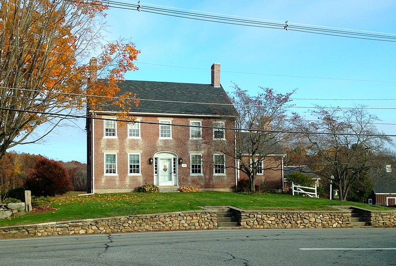
The Aldrich family were Quakers and their community included their homes, businesses including the Jacob Aldrich Farm (and Orchard) at 389 Aldrich Street which is a light colored brick home made in a kiln nearby on River Road. The Jacob Aldrich Farm and Orchard is located on Massachusetts Route 98, in a village of similar homes from the 18th and 19th century. The house is 2-1/2 stories in height, with end chimneys and a side gable roof. The main facade is five bays wide and symmetrical, with a center entrance flanked by sidelight windows and narrow pilasters, which rise to a semi-oval Federal-style fan. The brickwork is somewhat unusual, with the occasional use of square bricks on the outer walls.
Simeon Wheelock House
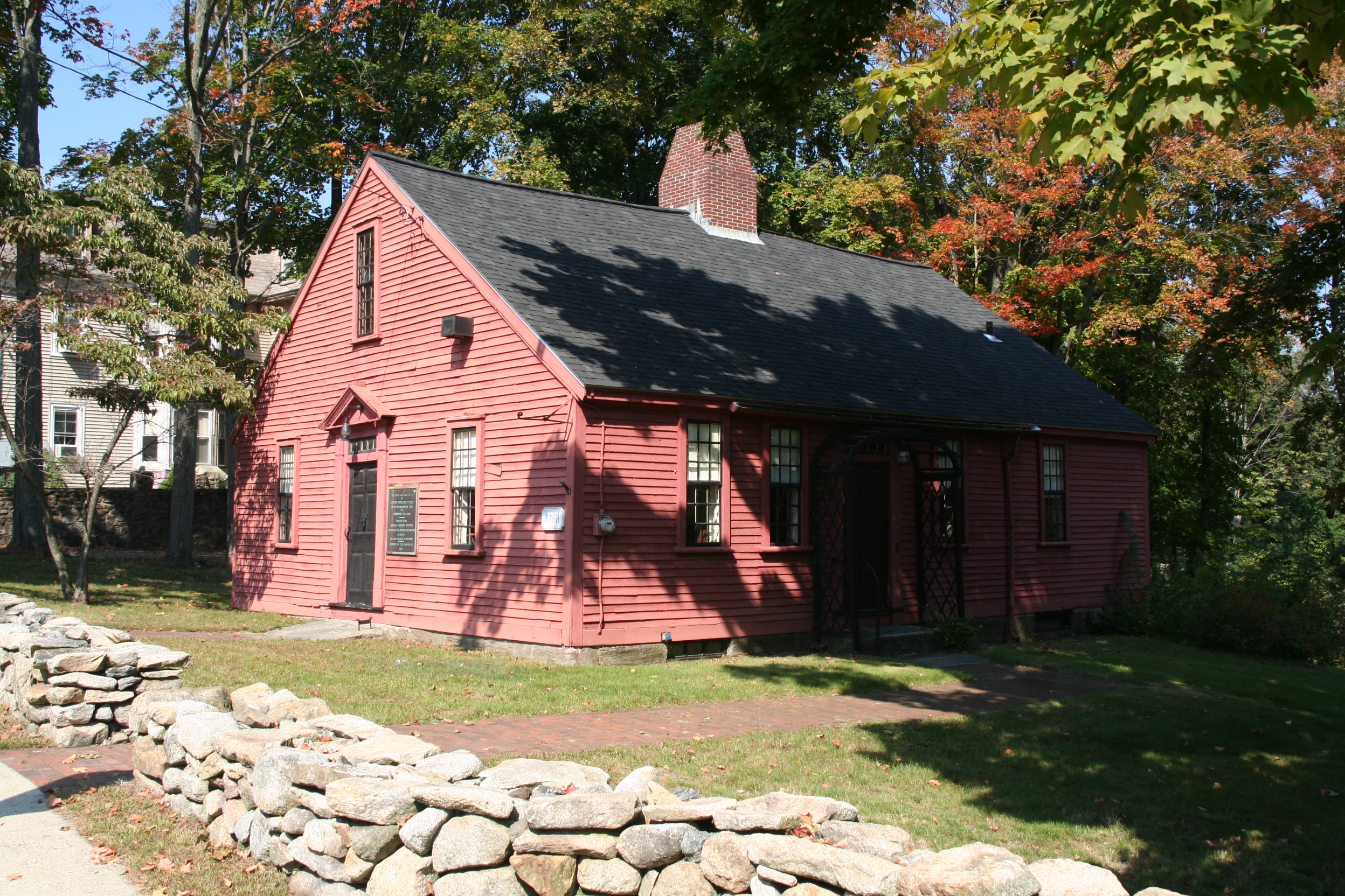
The home that Simeon and Deborah Wheelock built is now part of Uxbridge's many historic houses. It is located on North Main Street across from the Masonic Lodge building. Today, it is the local home of the Daughters of the American Revolution and is named for Deborah Wheelock. The building is well preserved as a museum. It was built in 1768 and is located at 33 North Main Street. There are a number of Revolutionary War soldiers and officers from this community. To find more on other soldiers, see the article on Uxbridge, Massachusetts. For more on historical sites in this area see the List of Registered Historic Places in Uxbridge, Massachusetts. This house is in the "Uxbridge Common Historic District" on Massachusetts Route 122 just north of Massachusetts Route 16. Simeon Wheelock was a blacksmith from Uxbridge, Massachusetts, who served as a minuteman in the Massachusetts militia during the battles of Lexington and Concord in the American Revolutionary War. After the war he was killed while on militia duty protecting the Springfield Armory during Shays' Rebellion.
Mumford River Falls
The Mumford River is an 18.3-mile-long river in south-central Massachusetts. It is a tributary of the Blackstone River. The river rises from its headwaters in Sutton and Douglas at Manchaug Pond and flows east in a meandering path through a series of ponds (Manchaug, Stevens, Gilboa, Lackey, and Whitins, just west of Whitinsville), and joins the Blackstone River in Uxbridge. The Mumford River Falls at Uxbridge powered America's fist Power looms for the woolen industry at John Capron's historic mill. The river was named for a hunter, named Mumford, at Mendon, who drowned in this river in the 17th century. This occurred before the towns through which this river flows were formed from Mendon. These towns include Douglas, Sutton, Northbridge, and Uxbridge. Mendon was first settled in 1660. This river was a source of water power for a number of mills and factories in America's earliest industrialization, in the historic Blackstone Valley. The Whitin Machine Works grew up at Whitinsville on the Mumford River, and was once the largest manufacturer of textile machines in the world. The Linwood Mill and the Crown and Eagle Mill at North Uxbridge also grew up on the Mumford, as did the historic Capron Mill at Uxbridge, and the Winfield Shuster Mill in East Douglas.
The Friends Meeting House
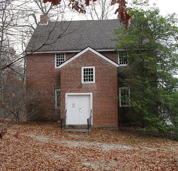
The Friends Meetinghouse is an historic Friends Meeting House of the Religious Society of Friends (Quakers) located at the junction of Routes 146A (Quaker Highway) and 98 (Aldrich Street) in Uxbridge, Massachusetts. On January 24, 1974, it was added to the National Register of Historic Places. The Friends Meeting House is one of the last crude brick church structures remaining in America. This building is on the National Registry of Historic Buildings. The Friends Meeting House was built in Uxbridge, Massachusetts in 1770, by Quakers from the Quaker Community in Smithfield, Rhode Island. It was built on the farm of Moses Farnum, circa 1769, from bricks made from a brickyardacross the street. The structure is two stories and has a balcony. In the Quaker tradition, there were separate entrances and meeting places for men and women. The "Quaker City" settlement is one of the earliest resettlements of Quakers into the Massachusetts Colony following their expulsion by the Puritans in the 17th century.
Coronet John Farum House
The Coronet John Farnum, Jr. House, built circa 1710, is one of the
oldest homes in the historic Blackstone Valley town of Uxbridge,
Massachusetts. On November 7, 1983, it was added to the National
Register of Historic Places. Uxbridge is in the heart of the Blackstone River Valley National Heritage Corridor, which is the oldest industrialized region in the United States. The Coronet John Farnum, Jr., House was the site of the first Uxbridge Town Meeting in 1727. The house today is a museum and headquarters of the Uxbridge Historical Society. It is an excellent example of early New England colonial architecture. John and Mary (Tyler) Farnum may have moved to the Chockalog section of Uxbridge, then Mendon, because of the "witchcraft controversies" that involved Mary's family in Andover. John Farnum, Jr. was a "coronet", a now obsolete military position similar to an ensign. He was elected a constable in Mendon in 1703. He had his house built about 1710 in a part of Mendon that is now Uxbridge. Son Moses Farnum's house still stands on Massachusetts Route 146A. On June 27, 1727 a petition was granted to form the town of Uxbridge. The first town meeting was held in the Coronet John Farnum House. One of the first official acts of the town on July 8,
1728, was to appropriate funds for "ÿe good rum for ye raising of ye
meeting house." The significance of the house, the town and Coronet
John Farnum, Jr., is now linked to American history as part of the
Blackstone River Valley National Heritage Corridor.
River Bend Farm
River Bend Farm is a Visitor's center as well as a Heritage State Park, created out of the former Voss farm, and located at 287 Oak Street, Uxbridge which extends into Northbridge, Millville and Blackstone, too. There are trails, picnic areas, canoe access, watchable wildlife, interpretive tours, special programs and even Sunday summer concerts. The Visitor Center is open daily during daylight hours offering tourism literature and often, a park ranger. There are very special events during the year, including the Colonial Muster weekend in October and much more. River Bend Farm is a great place to roam/kayak/hike and view the scenic
confluence of the old Blackstone Canal, the old arch bridge, the Rice City Pond and the old Stanley Woolen Mill down the canal path.
Charles Capron House
The Capron House is prominently located at the corner of Capron and Mendon Streets, a short way east of Uxbridge's downtown area. It is a 2-1/2 story wood frame structure, with a mansard-style truncated hip roof, clapboard siding, and a granite foundation. Its main facade, facing southeast, is three bays wide, sheltered by a highly decorated open porch that joins the space between flanking
polygonal window bays. A gable breaks the roof line above the entrance, and is decorated with Gothic woodwork, as are the dormers piercing the roof. Gothic details are continued on the flanking sides, and on the attached ell. The carriage barn at the rear of the property is a period structure; it is a two-story wood-frame structure, with a clipped gable roof topped by a cupola.
The house was built in 1874 by Charles Capron, a member of the locally prominent Capron family who was one of the owners of the Capron Mill, and was responsible for the introduction of electricity into Uxbridge. Capron was also active in civic affairs, serving as town treasurer, town clerk, selectman, and as a state representative. The house is Uxbridge's finest example of Gothic Revival architecture.
The Capron Mill, started by John Capron, the father, was made famous for military uniforms which were made here from at least the Civil War period, up through World War II, and including "the first U.S. Air Force uniform" which became known as the "Uxbridge Blue" During John Capron's tenure, the mills of Uxbridge including Capron Mills ran 24/7 during the American Civil War producing military uniforms. This mill later became the Bernat Mill known for yarns in the later 20th century, and was the third largest yarn factory in the U.S. On 21 July 2007, this historic mill, begun by Colonel Capron's family, was nearly totally destroyed, in the 10-alarm Bernat Mill Fire at Uxbridge. The oldest part of the historic mill, the original Capron Mill, made of wood, was virtually completely saved from the fire. The fire burned 400,000 square feet of the more modern brick-and-steel complex at Mendon and Depot Streets.
Blackstone River
The river is formed in Worcester, Massachusetts by the confluence of the Middle River and Mill Brook. From there, it follows a rough southeast course through Millbury, Sutton, Grafton, Northbridge, Uxbridge, Millville, and Blackstone. It then continues into Rhode Island, where it flows through Woonsocket, Cumberland, Lincoln, Central Falls, and Pawtucket, where the river then reaches Pawtucket Falls. After that, the river becomes tidal, and changes its name to the Seekonk River. Other tributaries join the Blackstone along the way, such as the West and Mumford River, at Uxbridge, and The Branch River in North Smithfield. The river is named after William Blackstone (original spelling William Blaxton) who arrived in Weymouth, Massachusetts in 1623, and became the first settler of present day Boston in 1625. He relocated again, to Rhode Island in 1635 and built his home on the river, in what would become Cumberland. With the Providence River, the Blackstone was the northeastern border of Dutch claims for New Netherland from Adriaen Block's charting of Narragansett Bay in 1614 through the Hartford Treaty of 1650. The original native American name for the river was the "Kittacuck", which meant "the great tidal river". The "Kittacuck", or Blackstone, was plentiful with Salmon and Lamprey in pre-colonial and colonial times. In 1790, Samuel Slater built the second cotton mill in America, Slater Mill, at Pawtucket Falls. This mill was powered by the waters of the Blackstone River. Many other mills appeared along the Blackstone River over time, giving the river the nickname "America's hardest working river." The industrialization also lead to the river being identified by the end of the 20th century as the primary source of Narragansett Bay pollution. In August 1955, severe flooding on the Blackstone caused extensive damage to Woonsocket, Rhode Island. Where the river is usually 70 feet (21 m) wide it swelled to over 1 mile (1.6 km) wide. The flooding of the Blackstone was the result of a succession of dam breaks and was caused by rainfall from Hurricane Connie followed a week later by Hurricane Diane which together deposited over twenty inches of rain in parts of Rhode Island and Massachusetts. The Blackstone river reached a stage of 21.8 feet in Woonsocket, which remains the flood of record; flood stage is 9.0 feet. The river, together with the Woonasquatucket River to the south, was designated an American Heritage River in 1998.
Uxbridge Town Common
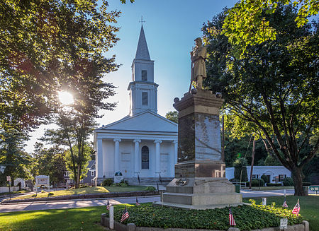
The Commons contains various mounuments to veterans who served in WWI, Korea, Vietnam, Civil War and one monument convering Afganistan, Iraq and other skimishes. Interestingly there is not a memorial to WWII.
The town was named after the Earl of Uxbridge, in Uxbridge, England, and it was one of the earliest leaders in the American Industrial Revolution.
For those who enjoy golf, Blissful Meadows Golf Club is located in Uxbridge on Chockalog Road. In addition, there are many public golf courses located within a short drive of Uxbridge. There are several other outdoor activities such as the River Bend Farm, Purgatory Chasim, Cormier Woods, and the like available. Additionally, the City of Worcester is home to the Railers, an East Coast Hockey League team affiliated with the New York Islanders, and the WooSox which is the Triple A farm team of the Boston Red Sox in addition to several Museums and theatres.
Town Common
More informationCapron House
More information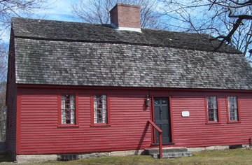
John Cornet Farum
House

Uxbridge Free
Public Library

Alice Bridges
More information
Mumford Falls
More informationNestled in a historic Blackstone Valley mill building, Bernat Antiques is a haven for collectors and enthusiasts seeking unique pieces to add to their homes. With a focus on authenticity and charm, the shop also features new gift items alongside its impressive selection of antiques.
89 Elmdale Rd
Uxbridge, MA 01569
508-278-5525
Directions
Town of Uxbridge
| History of Uxbridge Uxbridge is a town in Worcester, County, in Massachusetts, first colonized in 1662 and incorporated in 1727. It was originally part of the town of Mendon and named after the Earl of Uxbridge. The town is located 36 miles southwest of Boston and 15 miles south-southeast of Worcester. The history of Uxbridge can be divided into its colonial history and its modern industrial history. For almost 100 years, its economy was based principally on agriculture. However, in 1810, the course of its history changed dramatically when Uxbridge became the site of the first woolen mills in New England; and thus, it became a center of the earliest industrialized region in the United States. Read more . . . Medical Facilities There are several Primary Care medical facilities servicing the Uxbridge area. The Tri-River Family Health Center is located in Uxbridge, and the Milford Regional Physician Group is located in Northbridge and several other communities. The major medical facility in the area is the Milford Regional Medical Center (MRMC) and Emergency Center. Major medical facilities in the city of Worcester also serve the Uxbridge area. Urgent Care facilities are also located in Northbridge, Milford, Franklin. Tax Assistance and Personal Property Exemptions The Town of Uxbridge in conjunction with the Commonwealth of Massachusetts provide Personal Property Tax Exemptions to citizens who are either Veterans or Senior Citizens. For more information, click the link below: Assistance & Exemptions |
Links and Phone Numbers Below are links and phone numbers to various town departments and utility companies Town Website Police Department 508-278-7755 Fire Department Public Works 508-278-2787 508-278-8616 Uxbridge Public Library 508-278-8624 Eversource Customer Service 1-800-592-2000 Carbon Monoxide Information Read National Grid Customer Service 1-800-322-3223 Outages/Emergencies 1-800-465-1212 Restaurants and Shopping Uxbridge, and the surrounding towns, offer a variety of eating experiences from locally owned cafes, pizza establishments, and restaurants to nationally owned restaurant chains. There is something for everyone. If you prefer to do your own cooking, you should be able to find all the ingredients you need at the local Hannaford, Shaws, or Big Y grocery stores; or, at the Super Walmart grocery store in nearby Whitinsville. For your shopping needs, there are local shops in the Uxbridge - Whitinsville area as well as major shopping facilities at The Shops at Blackstone Valley outdoor mall in Millbury, MA. (15 miles north off Rt. 146). Community Garden The Town of Uxbridge provides plots of land to community members for the purpose of allowing them to exercise their interest in gardening and sharing that interest with others. To learn more about the Community Garden click the link below. Community Garden |
Schools and Universities Uxbridge is serviced by three school systems in the area: Uxbridge Public Schools 508-278-8648 Our lady of the Valley Regional 508-278-5851 Blackstone Valley Regional Vocational-Technical High School 508-529-7758 For higher education, there are 8 colleges and universities in the City of Worcester with an additional 6 colleges and universities in nearby cities and towns. Uxbridge CodeRed System CodeRED is an emergency notification service by which public safety can notify residents and businesses by email, telephone, or cellular phone about emergency situations occurring within the town of Uxbridge. Residents of Liberty Estates are encouraged to sign up for the system. To sign up for the CodeRED notification system, click the following link: Sign Up Emergency Key Access Program This program allows emergency responders to . . . Read |


